You are using an out of date browser. It may not display this or other websites correctly.
You should upgrade or use an alternative browser.
You should upgrade or use an alternative browser.
When is the Snow Gonna Fly in Deep Creek? -> Karma Contest!
- Thread starter j8064
- Start date
The #1 community for Gun Owners of the Northeast
Member Benefits:
No ad networks! Discuss all aspects of firearm ownership Discuss anti-gun legislation Buy, sell, and trade in the classified section Chat with Local gun shops, ranges, trainers & other businesses Discover free outdoor shooting areas View up to date on firearm-related events Share photos & video with other members ...and so much more!
Member Benefits:
j8064
Garrett Co Hooligan #1
It's my dad's bday
Happy B-Day to your Dad!

If the snow flies, it would be a karma two-fer for you...
")
Tomcat
Formerly Known As HITWTOM
Well, now... After re-reading recent posts I have a karma rules exception decision to make:
Based on the updated karma rules I posted on Jan 6 (because the snow hasn't flown) --- and because the good faith predictions quoted in the posts below by both Overboost44 and hitwtom who wanted to place their bets on Jan 18 --- I made an executive Hooligan decision.
Their predictions would be disqualified under the karma rules because they were not made >14 days in advance. However, Jan 18, 2016 would have been my Mom's 87th birthday - her picture is below.
With all that said and in fairness: If the snow flies on Jan 18, both predictions will stand and both predictors will receive the karma prize.
Also, each of their alternate prediction dates remain valid.
My mother was one of a kind. She would have wanted it that way...
As stated in my post my revised guess it the 27th. I only threw in the 18th in there since some of my research showed that day. If it happens give Overboost44 the Karma, he picked that date first.
God bless your mom.
j8064
Garrett Co Hooligan #1
Could this be the 3" event we've been waiting for to close out the karma?

Please correct me if I missed it, but no one that I can find in the thread predicted Jan 12. However we have protegeV's prediction of Jan 13.
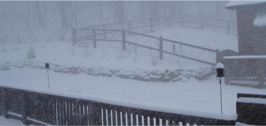
I don't plan on staying up overnight tomorrow (Jan 12) to measure the snowfall. But I'll monitor it until about 10 PM. Depending on what happens - if it happens - I'll use my judgement to fairly call 3" by early Wednesday morning.
In the meantime I'm told by Mrs. J they are making a lot of snow at the WISP. Whatever natural snow falls will augment their efforts. They are open for skiing!
Edit/Update:
Based on the NWS Advisory @ & 7PM tonight... I'm going to call whether or not we reach 3" when the snow event moves out. Looks like some cold sh*t is on its way...
Please correct me if I missed it, but no one that I can find in the thread predicted Jan 12. However we have protegeV's prediction of Jan 13.
I don't plan on staying up overnight tomorrow (Jan 12) to measure the snowfall. But I'll monitor it until about 10 PM. Depending on what happens - if it happens - I'll use my judgement to fairly call 3" by early Wednesday morning.
In the meantime I'm told by Mrs. J they are making a lot of snow at the WISP. Whatever natural snow falls will augment their efforts. They are open for skiing!
From the NWS 01/11/2016 @ 5:45PM:
- Tonight: A chance of snow, mainly after 2am. Increasing clouds, with a temperature falling to near 16 by 8pm, then rising to around 26 during the remainder of the night. Southwest wind 8 to 11 mph. Chance of precipitation is 50%. Total nighttime snow accumulation of less than a half inch possible.
- Tuesday: Snow showers. Temperature rising to near 28 by 10am, then falling to around 18 during the remainder of the day. Breezy, with a southwest wind 15 to 20 mph, with gusts as high as 34 mph. Chance of precipitation is 100%. New snow accumulation of 1 to 3 inches possible.
- Tuesday Night: Snow showers likely, mainly before 2am. Mostly cloudy, with a low around 6. Wind chill values as low as -11. Breezy, with a west wind 16 to 21 mph, with gusts as high as 33 mph. Chance of precipitation is 60%. New snow accumulation of 1 to 2 inches possible.
- Wednesday: A chance of snow showers, mainly before 9am. Partly sunny, with a high near 16. Wind chill values as low as -12. West wind 13 to 15 mph. Chance of precipitation is 30%.
Edit/Update:
Based on the NWS Advisory @ & 7PM tonight... I'm going to call whether or not we reach 3" when the snow event moves out. Looks like some cold sh*t is on its way...
...WINTER WEATHER ADVISORY IN EFFECT FROM 5 AM TUESDAY TO 7 AM
EST WEDNESDAY...
THE NATIONAL WEATHER SERVICE IN PITTSBURGH HAS ISSUED A WINTER
WEATHER ADVISORY FOR SNOW AND WIND GUSTS...WHICH IS IN EFFECT FROM 5 AM TUESDAY TO 7 AM EST WEDNESDAY.
* SNOW ACCUMULATION...2 TO 4 INCHES WITH LOCALLY HIGHER AMOUNTS ON THE HIGHEST ELEVATIONS.
* SNOW BEGINNING...IN THE PREDAWN OF TUESDAY AS LIGHT TO MODERATE SNOW.
* PERIOD OF MOST INTENSE SNOW...9 AM TO 7 PM AS SNOW TRANSITIONS TO HEAVIER SNOW SHOWERS...WHICH WILL CONTINUE INTO THE NIGHT.
* SNOW ENDING...SNOW SHOWERS WILL DIMINISH THROUGH THE PREDAWN OF WEDNESDAY. WIND CHILL INDICES MAY BE AROUND 10 BELOW ZERO BY THAT TIME.
Last edited:
j8064
Garrett Co Hooligan #1
As stated in my post my revised guess it the 27th. I only threw in the 18th in there since some of my research showed that day. If it happens give Overboost44 the Karma, he picked that date first.
God bless your mom.
That's fair, Tom. Jan 18 is still over a week away. We'll see what happens in the meantime.
No way Tom, yours actually took research! If it comes down to it, you deserve it. Besides, I like you.
Tomcat
Formerly Known As HITWTOM
No way Tom, yours actually took research! If it comes down to it, you deserve it. Besides, I like you.
I still owe you a stuffed ham recipe. I keep forgetting to dig it out of the kitchen drawer.
llkoolkeg
Hairy Flaccid Member
I'm in for 01/28/16 but I truly believe you will have already selected a winner before then.
BUFF7MM
☠Buff➐㎣☠
I'm in for 01/28/16 but I truly believe you will have already selected a winner before then.
Well Garrett County schools dismissed 3 hours early today, but I'm not seeing it happen today unless it picks up a good bit.
j8064
Garrett Co Hooligan #1

BUFF7MM
☠Buff➐㎣☠
East end of the county.


j8064
Garrett Co Hooligan #1

As much as I miss my house and many friends out there, seeing this helps me accept selling there.
Enjoy!
Enjoy!
j8064
Garrett Co Hooligan #1
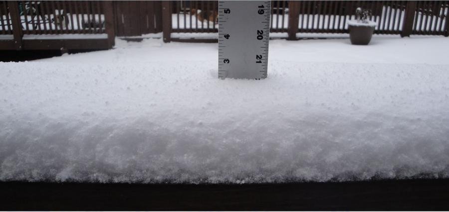
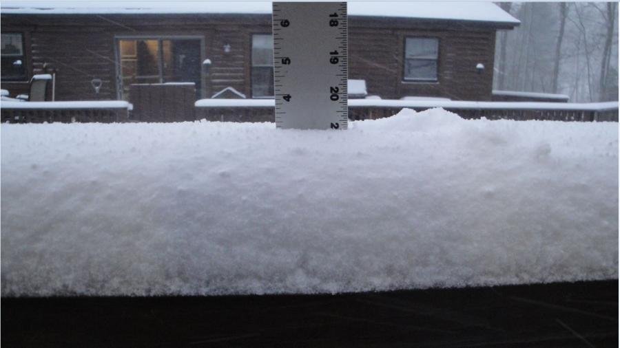
3 Inches!
As of 5:05PM Jan 12, 2016 we officially have 3" of snow on my office deck rail.
The Snow has Flown in Deep Creek!
Now the question is what to do about the karma? No one predicted Jan 12! protegeV predicted Jan 13. His prediction was certainly the closest, but being "closest" wasn't part of the original rules. Oops.
I'm thinking two things here:
- The Winter Weather Advisory about this storm that brought >3" won't be over until 0700 tomorrow -> Jan 13.
- While "technically" we have the magic number documented, the actual "snow event" of Jan 12-13 is what brought > 3" of snow.
I could call it for protegeV now and be done. But - I'll leave that call up to the OTHER members who made predictions...
The question is: Should protegeV be declared the karma winner based on his prediction?
A simple or  will do. I'll tally the thumbs in the morning. If I have no decisions or input either way by 8:00 AM tomorrow, protegeV wins.
So, what say you MDS Members?
(Oh, and protegeV, you can't vote...)
As of 5:05PM Jan 12, 2016 we officially have 3" of snow on my office deck rail.
The Snow has Flown in Deep Creek!
Now the question is what to do about the karma? No one predicted Jan 12! protegeV predicted Jan 13. His prediction was certainly the closest, but being "closest" wasn't part of the original rules. Oops.
I'm thinking two things here:
- The Winter Weather Advisory about this storm that brought >3" won't be over until 0700 tomorrow -> Jan 13.
- While "technically" we have the magic number documented, the actual "snow event" of Jan 12-13 is what brought > 3" of snow.
I could call it for protegeV now and be done. But - I'll leave that call up to the OTHER members who made predictions...
The question is: Should protegeV be declared the karma winner based on his prediction?
A simple
or will do. I'll tally the thumbs in the morning. If I have no decisions or input either way by 8:00 AM tomorrow, protegeV wins.So, what say you MDS Members?
(Oh, and protegeV, you can't vote...)
Attachments
Even though I didn't play. Congrats on the snow
plumberone
Active Member
Finally a little snow
I was off by more than a month
I was off by more than a month
Well, no one put more posts in here than he did. Then again you can say that in just about every thread on the forum.
pro1742
Active Member
Thumbs up
Users who are viewing this thread
Total: 2 (members: 0, guests: 2)

Forum statistics
Latest threads
-

-

-
-
NYC and StunGuns: maybe caetano ban was ok, if you use different “reason” (2 Viewers)
- Started by delaware_export
- Replies: 0
-

-

-